Marshfield station
Marshfield was a rapid transit station on the Chicago "L". Constructed by the Metropolitan West Side Elevated Railroad, it was the western terminus of the Metropolitan's main line, which then branched into three branches: the northwestern Logan Square branch, the western Garfield Park branch, and the southwestern Douglas Park branch. The station was in service from 1895 to 1954, when it, alongside the main line and the Garfield Park branch, was demolished to make way for the Eisenhower Expressway and the rapid transit Congress Line in its median. In addition to its use on the "L", Marshfield was served by the Chicago Aurora and Elgin Railroad (CA&E), an interurban that used the Garfield Park branch and main line's tracks, between 1905 and 1953.
MARSHFIELD 1700W 400S | |||||||||||||||||||||||||||||||||||||||||||||||||||||||||||||||||||||||||||||||||||||||||||||||||||||||||||||||||||||||
|---|---|---|---|---|---|---|---|---|---|---|---|---|---|---|---|---|---|---|---|---|---|---|---|---|---|---|---|---|---|---|---|---|---|---|---|---|---|---|---|---|---|---|---|---|---|---|---|---|---|---|---|---|---|---|---|---|---|---|---|---|---|---|---|---|---|---|---|---|---|---|---|---|---|---|---|---|---|---|---|---|---|---|---|---|---|---|---|---|---|---|---|---|---|---|---|---|---|---|---|---|---|---|---|---|---|---|---|---|---|---|---|---|---|---|---|---|---|---|---|
| Former Chicago "L" station | |||||||||||||||||||||||||||||||||||||||||||||||||||||||||||||||||||||||||||||||||||||||||||||||||||||||||||||||||||||||
 A pre-WWI view looking east at the station. The CA&E's platform is in the foreground. | |||||||||||||||||||||||||||||||||||||||||||||||||||||||||||||||||||||||||||||||||||||||||||||||||||||||||||||||||||||||
| General information | |||||||||||||||||||||||||||||||||||||||||||||||||||||||||||||||||||||||||||||||||||||||||||||||||||||||||||||||||||||||
| Location | 416 South Marshfield Avenue Chicago, Illinois | ||||||||||||||||||||||||||||||||||||||||||||||||||||||||||||||||||||||||||||||||||||||||||||||||||||||||||||||||||||||
| Coordinates | 41.875742°N 87.66825°W | ||||||||||||||||||||||||||||||||||||||||||||||||||||||||||||||||||||||||||||||||||||||||||||||||||||||||||||||||||||||
| Owned by | Chicago Transit Authority (1947–1954) Chicago Rapid Transit Company (1924–1947) See text before 1924 | ||||||||||||||||||||||||||||||||||||||||||||||||||||||||||||||||||||||||||||||||||||||||||||||||||||||||||||||||||||||
| Line(s) | |||||||||||||||||||||||||||||||||||||||||||||||||||||||||||||||||||||||||||||||||||||||||||||||||||||||||||||||||||||||
| Platforms | 2 island platforms and 1 side platform | ||||||||||||||||||||||||||||||||||||||||||||||||||||||||||||||||||||||||||||||||||||||||||||||||||||||||||||||||||||||
| Tracks | 4 | ||||||||||||||||||||||||||||||||||||||||||||||||||||||||||||||||||||||||||||||||||||||||||||||||||||||||||||||||||||||
| Construction | |||||||||||||||||||||||||||||||||||||||||||||||||||||||||||||||||||||||||||||||||||||||||||||||||||||||||||||||||||||||
| Structure type | Elevated | ||||||||||||||||||||||||||||||||||||||||||||||||||||||||||||||||||||||||||||||||||||||||||||||||||||||||||||||||||||||
| Bicycle facilities | Yes | ||||||||||||||||||||||||||||||||||||||||||||||||||||||||||||||||||||||||||||||||||||||||||||||||||||||||||||||||||||||
| History | |||||||||||||||||||||||||||||||||||||||||||||||||||||||||||||||||||||||||||||||||||||||||||||||||||||||||||||||||||||||
| Opened | May 6, 1895 | ||||||||||||||||||||||||||||||||||||||||||||||||||||||||||||||||||||||||||||||||||||||||||||||||||||||||||||||||||||||
| Closed | April 4, 1954 | ||||||||||||||||||||||||||||||||||||||||||||||||||||||||||||||||||||||||||||||||||||||||||||||||||||||||||||||||||||||
| Key dates | |||||||||||||||||||||||||||||||||||||||||||||||||||||||||||||||||||||||||||||||||||||||||||||||||||||||||||||||||||||||
| March 11, 1905 | AE&C (later CA&E) service introduced | ||||||||||||||||||||||||||||||||||||||||||||||||||||||||||||||||||||||||||||||||||||||||||||||||||||||||||||||||||||||
| February 25, 1951 | Logan Square and Humboldt Park service discontinued | ||||||||||||||||||||||||||||||||||||||||||||||||||||||||||||||||||||||||||||||||||||||||||||||||||||||||||||||||||||||
| September 20 and 27, 1953 | Garfield Park and CA&E service discontinued | ||||||||||||||||||||||||||||||||||||||||||||||||||||||||||||||||||||||||||||||||||||||||||||||||||||||||||||||||||||||
| Passengers | |||||||||||||||||||||||||||||||||||||||||||||||||||||||||||||||||||||||||||||||||||||||||||||||||||||||||||||||||||||||
| 1953 | 688,413  3.48% (CTA) 3.48% (CTA) | ||||||||||||||||||||||||||||||||||||||||||||||||||||||||||||||||||||||||||||||||||||||||||||||||||||||||||||||||||||||
| Rank | 68 out of 137 | ||||||||||||||||||||||||||||||||||||||||||||||||||||||||||||||||||||||||||||||||||||||||||||||||||||||||||||||||||||||
| Former services | |||||||||||||||||||||||||||||||||||||||||||||||||||||||||||||||||||||||||||||||||||||||||||||||||||||||||||||||||||||||
| |||||||||||||||||||||||||||||||||||||||||||||||||||||||||||||||||||||||||||||||||||||||||||||||||||||||||||||||||||||||
| |||||||||||||||||||||||||||||||||||||||||||||||||||||||||||||||||||||||||||||||||||||||||||||||||||||||||||||||||||||||
| Location | |||||||||||||||||||||||||||||||||||||||||||||||||||||||||||||||||||||||||||||||||||||||||||||||||||||||||||||||||||||||
 | |||||||||||||||||||||||||||||||||||||||||||||||||||||||||||||||||||||||||||||||||||||||||||||||||||||||||||||||||||||||


The Metropolitan was one of four companies establishing the "L"; with interruptions and financial issues, it operated until 1911, when it handed operations to Chicago Elevated Railways (CER), and formally merged into the Chicago Rapid Transit Company (CRT) in 1924. The "L" was taken over by the publicly-held Chicago Transit Authority (CTA) in 1947. The CA&E, on the other hand, was a descendant of the Aurora Elgin and Chicago Railway (AE&C), which became bankrupt in the aftermath of World War I and split into CA&E in 1921.
Substantial revisions to the lines that had been constructed by the Metropolitan had been planned since the 1930s; all told, they would replace the Logan Square branch with a subway to go directly downtown, and substitute a rapid transit right of way in the median of the Congress Superhighway for the main line and Garfield Park branch. The subway opened in 1951, removing Logan Square traffic from Marshfield. Construction then started on the Congress Line, which led to the Garfield Park trackage being replaced by temporary right of way and eliminating its service at Marshfield in 1953; at the same time, the CA&E also ended service on the affected route. This left Douglas Park trains as the sole users of the Marshfield station until April 1954, when they too used a temporary right of way to go downtown. The Congress Line opened in 1958; the junction that Marshfield had served was maintained between the new line and the Douglas Park branch, but no new station was constructed in the area.
History
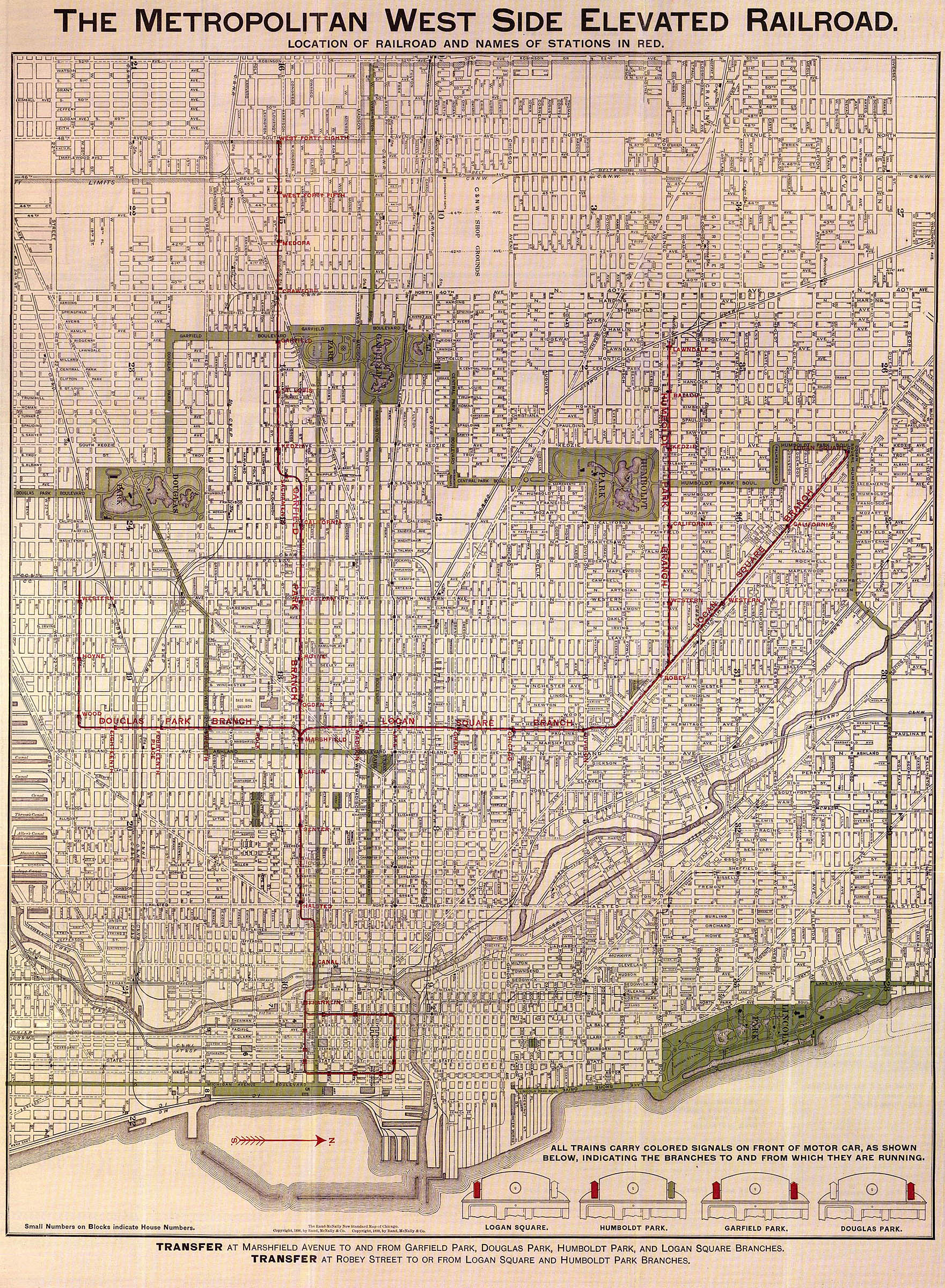
The Metropolitan West Side Elevated Railroad Company was granted a 50-year franchise by the Chicago City Council on April 7, 1892,[2] and began securing right of way shortly thereafter.[3] As designed, the Metropolitan's operations comprised a main line that went westward from downtown to diverge into three branches – one northwest to Logan Square, one due west to Garfield Park, and one southwest to Douglas Park – and serve various parts of Chicago's west side.[4] A further branch to Humboldt Park would proceed due west from the Logan Square branch past Robey Street.[lower-alpha 2][4][5] The franchise stipulated that this divergence take place somewhere between Wood Street and Ashland Avenue; the Metropolitan decided to place the junction at Marshfield Avenue, a minor street.[2]
Originally intended to be powered by steam locomotives like the competing South Side and Lake Street Elevateds, the Metropolitan decided in May 1894 to use electric traction instead;[8] the tracks had already been largely constructed prior to the decision to electrify them, but retrofitting the third rail proved an easy task outside of the switches of the main line.[9] The junction at Marshfield required "elaborate special work" in its switches and signals, more so than other elevated railroads at the time,[9] and has been described as being "the most elaborate and complex junction on the Chicago elevated system" as late as 1948.[10] The main line and Logan Square branch up to Robey[lower-alpha 2] had their tracks completed by the middle of October 1894, and were given power in April 1895 for test and inspection runs.[5] They began service at 6 a.m. on Monday, May 6, 1895; eleven stations opened that day, including Marshfield.[11] Upon its opening, the Metropolitan became the first revenue electric elevated railroad in the United States.[12] The Garfield Park branch opened on June 19, but the Douglas Park branch was delayed until April 28, 1896.[13]
The Metropolitan's lines were originally operated by the West Side Construction Company, which had been responsible for constructing them, and would be transferred to the Metropolitan on October 6, 1896.[14] The backers and officers of the two companies were largely identical, however, so this transfer of ownership was nominal.[4][14] The expenses incurred in constructing the Metropolitan's vast trackage would catch up to the company, which entered receivership in 1897; the similarly-named Metropolitan West Side Elevated Railway Company was organized in January 1899 and assumed operations on February 3 of that year.[15]
The interurban Aurora Elgin and Chicago Railroad (AE&C) was incorporated in 1901 and began service on August 25, 1902, between its terminal in Aurora and the Garfield Park branch's 52nd Avenue station in Chicago.[16] The AE&C and Metropolitan entered a trackage rights agreement in 1905, whereby AE&C trains were allowed to go into downtown Chicago via the Metropolitan's tracks and Wells Street Terminal and the Metropolitan could extend its service westward on AE&C tracks to its station on Des Plaines Avenue.[17] This agreement went into effect on March 11.[18] Having gone bankrupt in 1919 due to rising inflation from World War I and state regulations, the AE&C was split into two parts, one of which was the Chicago Aurora and Elgin Railroad (CA&E), in 1921.[17]
The Metropolitan, along with the other companies operating "L" lines in Chicago, became a part of the Chicago Elevated Railways (CER) trust on July 1, 1911.[19] CER acted as a de facto holding company for the "L" – unifying its operations, instituting the same management across the companies, and instituting free transfers between the lines starting in 1913 – but kept the underlying companies intact.[20] This continued until the companies were formally merged into the single Chicago Rapid Transit Company (CRT), which assumed operations on January 9, 1924; the former Metropolitan was designated the Metropolitan Division of the CRT for administrative purposes.[21] Although municipal ownership of transit had been a hotly-contested issue for half a century, the publicly-owned Chicago Transit Authority (CTA) would not be created until 1945,[22] or assume operation of the "L" until October 1, 1947.[18]
Closure and demolition
Plans for Chicago to have a subway system to relieve the severe congestion of, if not replace, its elevated trackage dated back to the early 20th century, but the city lagged in building subways.[23] Chicago petitioned the Public Works Administration (PWA) for construction funds for a subway on State Street in 1937.[24] The petition originally included a proposal for two downtown east-west streetcar tunnels.[25] Harold L. Ickes, the administrator of the PWA and a longtime Chicagoan, vetoed the streetcar tunnel plan and insisted instead on a Milwaukee-Dearborn subway that would provide a more direct route from Logan Square to downtown.[25] Although this idea engendered considerable local opposition, especially from mayor Edward Joseph Kelly, Ickes's influence in the federal government led to the Dearborn plan being adopted in 1938.[25] A 1939 plan also introduced the idea of replacing the main line and Garfield Park branch with a section of rapid transit operating through a superhighway (the eventual Interstate 290 or "Eisenhower") on Congress Street that had been proposed since the 1909 Plan of Chicago and more thoroughly planned in the early 1930s.[26][27] These sections of transit would be connected, allowing for the northwest side's rapid transit to be routed through downtown rather than adhere to a trunk-and-branch model.[28] Work soon began on the subway, which was 82 percent complete when World War II forced its suspension in 1942. It finally opened on February 25, 1951, rerouting Logan Square and Humboldt Park trains from Marshfield Junction.[lower-alpha 3][30]
Construction on the expressway and Congress Line, on the other hand, had not started even though it had been adopted by the City Council in 1940 and formally authorized for construction in 1946.[31] Clearance of the right of way began in 1949 and was largely complete by 1952.[27] Three different agreements were made between the CTA, Chicago, Cook County, and Illinois between 1951 and 1954 concerning the financing and ownership of the new construction, which soon commenced.[31] Changes were made to the Garfield Park and Douglas Park lines on December 9, 1951. Several stations were closed, primarily on the Douglas Park branch but also including Laflin to Marshfield's east on the main line. Skip-stop, wherein trains were designated either as "A" trains or "B" trains and stopped at respective "A" or "B" stations, was applied during weekdays to the surviving stations; Marshfield was designated an "all-stop" station under this scheme and was thus unaffected.[1]
As construction progressed, Garfield trains were rerouted from the "L" structure to temporary street-level trackage between Kedzie and Halsted, exclusive, ceasing to make intermediate stops in that interval, including the main line stations of Marshfield and Racine. In the process, Marshfield became a "B" station and Halsted became the transfer point between Garfield Park and Douglas Park trains. This change impacted westbound trains on September 20, 1953, and eastbound trains on September 27.[32] The CA&E, long struggling financially, refused to use the at-grade tracks due to safety concerns as well as the prospect of delays caused by the use of traffic signals at road crossings, and had serious doubts about its ability to reroute its right of way into the new expressway median;[33] despite some speculative plans for alternative train service to downtown Chicago, and after being disallowed by state regulators to abandon rail service altogether in favor of buses, the CA&E ultimately abandoned service east of Des Plaines on September 20, 1953.[34] This left Douglas Park trains as the sole remaining traffic for Marshfield and Racine, which remained temporarily open for them.[32]
Douglas Park trains started using the Paulina Connector to get to the Loop on April 4, 1954, removing the last traffic to Marshfield and Racine resulting in their closure; they were demolished soon afterwards.[35] After the change, Douglas Park riders needing to transfer to westbound Garfield Park trains were advised to use the Madison/Wells station in the Loop, whereas eastbound Garfield Park riders headed for Douglas Park were recommended to switch at State/Van Buren.[35] The Congress Line was complete in the area of Marshfield and opened on June 22, 1958, as part of the new "West-Northwest Route"; the route preserved Marshfield Junction between the Congress and Douglas Park lines, but with a new station on Racine Avenue as the final station before the divergence.[28][36] West of the junction on the Congress Line, the Medical Center station contained an auxiliary exit and part-time entrance on Paulina Street, a block west of Marshfield Avenue and immediately under the junction.[37]
Station details
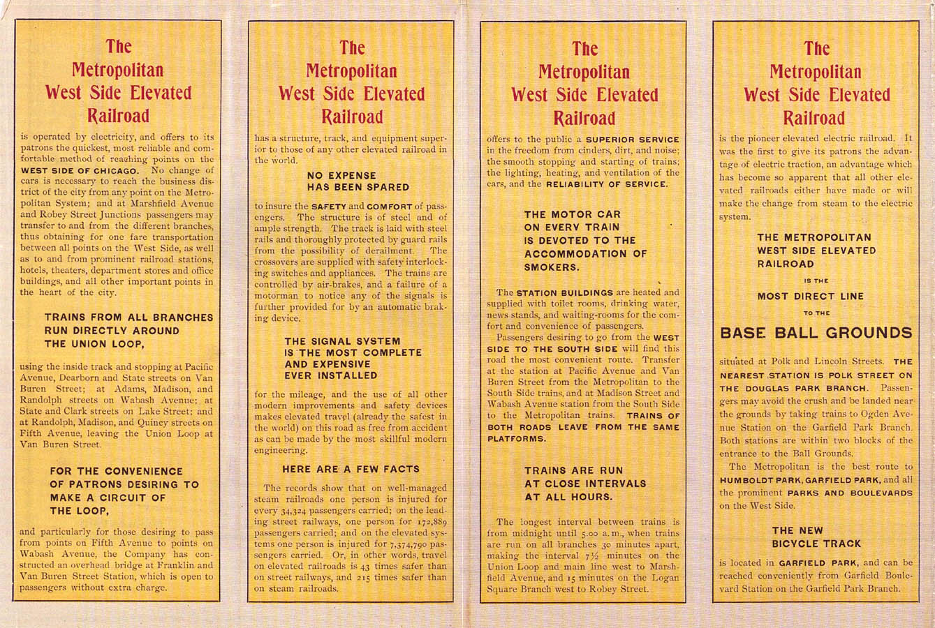
The station was located at 416 South Marshfield Avenue.[38] The Metropolitan boasted of providing water closets, water fountains, newsstands, and waiting rooms at its stations,[6] which also included racks for bicycles, staff to announce those in waiting rooms of approaching trains, and space for baby carriages.[14] Unlike elsewhere on the "L", the Metropolitan's station houses had central heating and basements.[14]
Marshfield had two island platforms, one each between an inner and outer track. East of the station, trains crossed over such that the northern tracks and southern tracks were each a bidirectional pair; trains bound for or coming from Logan Square and Humboldt Park would use the northern tracks and island platform, while trains bound for or coming from Garfield Park and Douglas Park used the southern tracks and platform. Three switches existed at this interlocking, all of which were hand-thrown. An additional platform for CA&E trains existed on the northern Garfield Park track west of the "L" station; a pedestrian bridge linked both "L" platforms and the CA&E platform.[39][40] The junction's switches and signals were constructed by the Paige Iron Works of Chicago.[41] The tower for the junction was located on the southern island platform.[10] West of Marshfield, another junction involved the Douglas Park branch diverging from the Garfield Park tracks; this divergence, combined with the crossover, has led to descriptions of the junction as "actually consist[ing] of two junctions".[10]
Operations
_(14779275193).jpg.webp)
As originally opened, the Metropolitan's trains ran every six minutes between 6 a.m. and 6:30 p.m., and every ten minutes during the night; the average speed was 16 mph (26 km/h).[11] By 1898, this schedule was updated so that trains ran at 30-minute intervals on each branch, or 7.5 minutes on the main line.[6] Westbound trains serving the Westchester branch, a continuation of the Garfield Park branch from Des Plaines opened in 1926, were express operations and did not stop at Marshfield during weekday rush hours or most of Saturdays; patrons wishing to go to Westchester needed to board Garfield Park trains to Laramie to transfer to Westchester trains.[42][43] Unlike the Lake Street Elevated, which operated smoking cars at some times but not at others, all of the Metropolitan's motor cars allowed smoking.[11] Smoking was banned by the city across the "L" and in streetcars in response to a 1918 influenza outbreak, a prohibition that has remained in force ever since.[44] Nevertheless, the CA&E still allowed smoking as late as 1948, splitting its cars into smoking and non-smoking components.[45]
The CA&E stopped at Marshfield to board westbound passengers and alight eastbound passengers; lest it compete with the "L" directly, patrons were not allowed to board eastbound trains at Marshfield, nor were westbound passengers allowed to alight at stations within the "L"'s area of service.[46] As early as 1934, several morning rush hour CA&E trains a day stopped at Laflin instead of Marshfield to discharge eastbound passengers.[47] By 1950, such trains, now the majority of morning rush hour trains, would instead use Ogden for eastbound alightment, although the remainder of CA&E trains continued eastbound alightment at Marshfield.[46] In the CTA era, CTA rules limited CA&E trains to 45 mph (72 km/h) on "L" tracks.[48] At the crossover east of Marshfield, CA&E trains were usually given priority over "L" trains lest the latter slow down CA&E service with their local service.[48]
The fare across the "L" was legally mandated to be a nickel (5 cents, $1.37 in 2021) in the late 19th and early 20th centuries. The nickel fare continued until temporarily increased by a cent to 6 cents in 1917 ($1.27 in 2021) before stabilizing to a dime in 1920 (10 cents, $1.35 in 2021).[49] Starting in 1922, fares were usually marketed in packs of three rides for 25 cents, or 8+1⁄3 cents per ride ($1.35 per ride in 2021), but individual fares remained 10 cents each.[50] At the same time, a weekly pass was introduced, the first in a major American city, for $1.25 ($20.24 in 2021) for rides outside of Evanston and Wilmette.[50] On the CA&E, the fare from Wells Street varied based on destination; ranging in 1934 from 28 cents to Hillside ($5.67 in 2021) to 75 cents to its various terminals ($15.19 in 2021). Round trip 10-day tickets, which required departure to be done on the same day as the ticket's purchase but allowed the return to be done at any time within the next 10 days, were sold as well, ranging from 55 cents to $1.35 ($11.14 to $27.35 in 2021) depending on destination, as well as monthly tickets for 54 and 60 rides, the latter ranging from $8.50 to $13.20 ($172.18 to $267.38 in 2021). The most expensive ticket sold by the CA&E was a 25-ride coupon good for a year after issue, which topped out at $17.16 at the terminals ($347.60 in 2021). The fare from Marshfield could have varied slightly from these prices.[47] By 1950, prices for fares were no longer advertised in time tables, but tickets continued to be sold in one-way; round-trip good for 30 days; yearly 10-ride and 25-ride; weekly 10-ride, 12-ride, and 14-ride; and monthly 60-ride configurations. Tickets sold on trains came with a dime ($1.13 in 2021) surcharge for full-fare tickets.[46]
Neighborhood and connections
Underneath the CA&E platform was the Dreamland Ballroom, a venue that was at one time owned by the CRT. Located near the station was the Coyne Electrical School and the Presbyterian Hospital. Also in the station's neighborhood was Chicago Stadium, more directly served by Madison on the Logan Square branch, and the headquarters of the retail cataloger Alden's.[48]
A streetcar ran on Ashland Avenue by the late 19th century; in the vicinity of the station, it turned west to run north from Paulina Avenue lest it run on a boulevard,[48] before turning back east to Ashland.[51] This route was through-routed from Clark Street down to 87th Street starting November 1, 1916.[52] This became known as "Through Route 9" (TR 9) in 1924.[51] By the early- to mid-20th century, Ashland was one of the "Big Five" streetcar lines in Chicago, which had the highest ridership, got the most amentities and had the shortest wait times.[53] As of 1928, TR 9 had owl service between 1 and 4:45 a.m., wherein streetcars ran every fifteen minutes;[54] during the day, streetcar lines in Chicago typically had intervals of between eight and fifteen minutes per car.[53] Buses replaced streetcars on weekends starting May 11, 1952, and altogether on February 13, 1954.[52]
In addition to the Ashland Avenue streetcar, one ran on Van Buren Street adjacent to the Metropolitan's tracks. Powered by horse until 1896, upon electrification it proceeded west from State Street to Kedzie Avenue.[55] Such streetcars were a competitor to the Metropolitan, siphoning many of its would-be passengers during the warm summer months as their cars were more open-air.[14] As of 1928, the Van Buren route had owl service between 1:03 and 4:42 a.m., where cars ran on intervals varying between 15, 24, and 30 minutes.[56] On October 11, 1937, the Van Buren route was through-routed with streetcar service on Division Street, about two miles (3.2 km) miles to the north, via downtown. This continued until Division Street service was replaced by buses and Van Buren streetcars were once again independent on February 4, 1951. This was short-lived, however, as buses replaced streetcars on Van Buren on August 12, 1951.[55]
Ridership
Marshfield's "L" ridership peaked at 1,538,319 in 1926 and last exceeded a million in 1929,[57] although it broke 900,000 in the mid-to-late 1940s.[58] In the last full year of its operation, 1953, Marshfield served 688,433 passengers on the "L", a 3.48 percent decline from the 713,264 of 1951; ridership statistics are unavailable throughout the entire "L" for 1952. For the part of 1954 it was open, Marshfield served 135,928 passengers.[59] For 1953, Marshfield was in the exact middle of the main line's ridership, surpassing Racine and Franklin/Van Buren but underperforming Canal and Halsted.[59] For the "L" system as a whole, Marshfield's 1951 performance made it the 65th-busiest of 131 "L" stations that were at least partially-manned at the beginning of the year, while in 1953 it was the 68th-busiest of 137 such stations. Accounting for the part of 1954 it was open, it had the 114th-highest patronage out of those 137 stations.[lower-alpha 4][63]
Although the CA&E did not collect ridership statistics by station, the railroad's total ridership was less than four million annually starting in 1949, and declining in that period of time. After the September 1953 suspension of direct "one-seat ride" service into Chicago, the railroad lost half of these riders by December as riders opted instead for the nearby Chicago and North Western Railroad (C&NW) or automobiles to get into the city.[64] Faced with this onslaught, the CA&E discontinued passenger service altogether at midday on July 3, 1957. Passengers who had taken the morning trains to Chicago were caught unaware by this development and had to find alternative transportation home.[65]
Notes
- Racine after 1951[1]
- Technically, the Logan Square branch started after Robey and was, like the Humboldt Park branch, a divergence from what was formally known as the "Northwest branch".[5] However, as early as 1898, even the Metropolitan itself was referring to the Northwest branch as part of the "Logan Square branch",[6] although ridership statistics continued to separate them.[7]
- Earlier plans had called for both the subway and old Logan Square trackage to be used for revenue service, but the CTA abandoned those plans.[29]
- The Humboldt Park, Normal Park, and Westchester branches, which all closed in the 1950s, had all of their stations unmanned by 1951 in favor of fare collection by on-train conductors, meaning that their stations did not collect ridership statistics.[60] The Garfield Park branch likewise did not collect ridership statistics by station in its final years.[61] Several stations closed on the "L" in 1951, while Central Park station was opened that year to replace several stations on the Douglas Park branch.[1] Ridership statistics for stations on the Lake Street Elevated and through stations on the Kenwood branch, last recorded in 1948 and 1949 respectively, returned in 1953.[62]
References
- "Revise Douglas and Garfield "L" Service Dec. 9". Chicago Tribune. Vol. 110, no. 288. December 1, 1951. p. 4. Retrieved November 24, 2022 – via Newspapers.com.
- Moffat 1995, p. 123
- 1895 Review, p. 263
- 1895 Review, p. 264
- Moffat 1995, p. 130
- The Metropolitan West Side Elevated Railroad (Map). Metropolitan West Side Elevated Railroad. 1898. pp. 1–2 – via Chicago-L.org.
- CTA 1979, pp. 10–14
- 1895 Review, p. 266
- 1895 Review, p. 267
- Weller & Stark 1999, p. 36
- "New "L" Road Opens". Chicago Tribune. Vol. 54, no. 127. May 7, 1895. p. 12 – via Newspapers.com.
- Borzo 2007, p. 43
- Moffat 1995, pp. 130–131.
- Moffat 1995, p. 134
- Moffat 1995, p. 139
- Weller & Stark 1999, pp. 2–3
- Weller & Stark 1999, p. 3
- Weller & Stark 1999, p. 131
- Moffat 1995, p. 237
- Moffat 1995, pp. 240–242
- Moffat 1995, p. 261
- Moffat 1995, p. 260
- Borzo 2007, p. 91
- Borzo 2007, p. 92
- "Entries in Loop at Every Block; Begin Work Dec. 15". Chicago Tribune. Vol. 97, no. 245. October 13, 1938. pp. 1–2. Retrieved November 17, 2022 – via Newspapers.com.
- CTA 1967, p. 9
- Weller & Stark 1999, p. 14
- CTA 1967, p. 5
- Banich, Terence. "Remnants of the "L"". Forgotten Chicago. Retrieved January 22, 2023.
- Buck, Thomas (February 18, 1951). "1st Trains Run in New Subway Saturday Night". Chicago Tribune. Vol. 110, no. 7, Part 1. p. 21. Retrieved October 16, 2022 – via Newspapers.com.
- CTA 1967, p. 10
- "Garfield Park-Douglas Park "L" Service Revisions". Chicago Tribune. Vol. 112, no. 226. September 21, 1953. p. 3–2. Retrieved February 5, 2023 – via Newspapers.com.
- Weller & Stark 1999, pp. 14–15
- Weller & Stark 1999, pp. 16–17
- "To Change 'L' Routing on Sunday". Berwyn Life. Vol. 22, no. 40. Berwyn, Illinois. April 2, 1954. p. 1. Retrieved October 4, 2022 – via Newspapers.com.
- "Announces Congress Subway Plan System for Trains". Berwyn Life. Vol. 26, no. 70. Berwyn, Illinois. June 11, 1958. p. 5. Retrieved October 16, 2022 – via Newspapers.com.
- CTA 1967, p. 6
- Polk Directory, p. 212
- Rapid Transit Map (PDF) (Map). Chicago Transit Authority. November 4, 1952. Retrieved February 6, 2023 – via Chicago-L.org.
- Weller & Stark 1999, pp. 36–37
- 1895 Review, p. 268
- Garfield, Graham. "Marshfield". Chicago-L.org. Retrieved October 1, 2022.
- Garfield, Graham. "Westchester branch". Chicago-L.org. Retrieved October 2, 2022.
- Moffat 1995, p. 115
- Weller & Stark 1999, p. 34
- Chicago Aurora and Elgin Railway (October 29, 1950). "Time Tables" (PDF). Chicago: Poole Bros., Inc. Retrieved February 9, 2023 – via GreatThirdRail.org.
- Chicago Aurora and Elgin Railroad (May 27, 1934). "Fast, Frequent Electrified Service between Chicago Loop, Western Suburbs, Fox River Valley" (PDF). Chicago: Poole Bros., Inc. Retrieved February 9, 2023 – via GreatThirdRail.org.
- Weller & Stark 1999, p. 37
- Moffat 1995, pp. 254–255
- Moffat 1995, p. 255
- Lind 1974, p. 221
- Lind 1974, p. 228
- Lind 1974, p. 201
- Lind 1974, p. 202
- Lind 1974, p. 309
- Lind 1974, p. 203
- CTA 1979, p. 12
- CTA 1979, p. 14
- CTA 1979, p. 15
- CTA 1979, pp. 15 & 23
- CTA 1979, p. 23
- CTA 1979, pp. 14–15 & 30–31
- CTA 1979, pp. 7, 15, 23, 31, & 39
- Weller & Stark 1999, p. 17
- Weller & Stark 1999, p. 20
Works cited
- "The Metropolitan West Side Elevated Railroad of Chicago". The Street Railway Review. 5: 263–274. January 15, 1895.
- Borzo, Greg (2007). The Chicago "L". Charleston, South Carolina: Arcadia. ISBN 9780738551005 – via Google Books.
- Public Information Department (1967). Congress Rapid Transit. Chicago: Chicago Transit Authority – via Internet Archive.
- CTA Rail Entrance, Annual Traffic, 1900–1979 (Report). Chicago: Chicago Transit Authority. October 1, 1979.
- Lind, Alan R. (1974). Chicago Surface Lines: An Illustrated History. Park Forest, Illinois: Transport History Press.
- Moffat, Bruce G. (1995). The "L": The Development of Chicago's Rapid Transit System, 1888–1932. Chicago: Central Electric Railfans' Association. ISBN 0-915348-30-6.
- "R. L. Polk & Co.'s Chicago Street and Avenue Guide" (PDF). Polk's Chicago Directory 1923. Chicago: R. L. Polk & Co. 1923. pp. 193–228 – via ChicagoAncestors.org.
- Weller, Peter; Stark, Fred (1999). The Living Legacy of the Chicago Aurora and Elgin. San Francisco: Forum Press. ISBN 0-945213-41-7 – via Internet Archive.