Fir'im
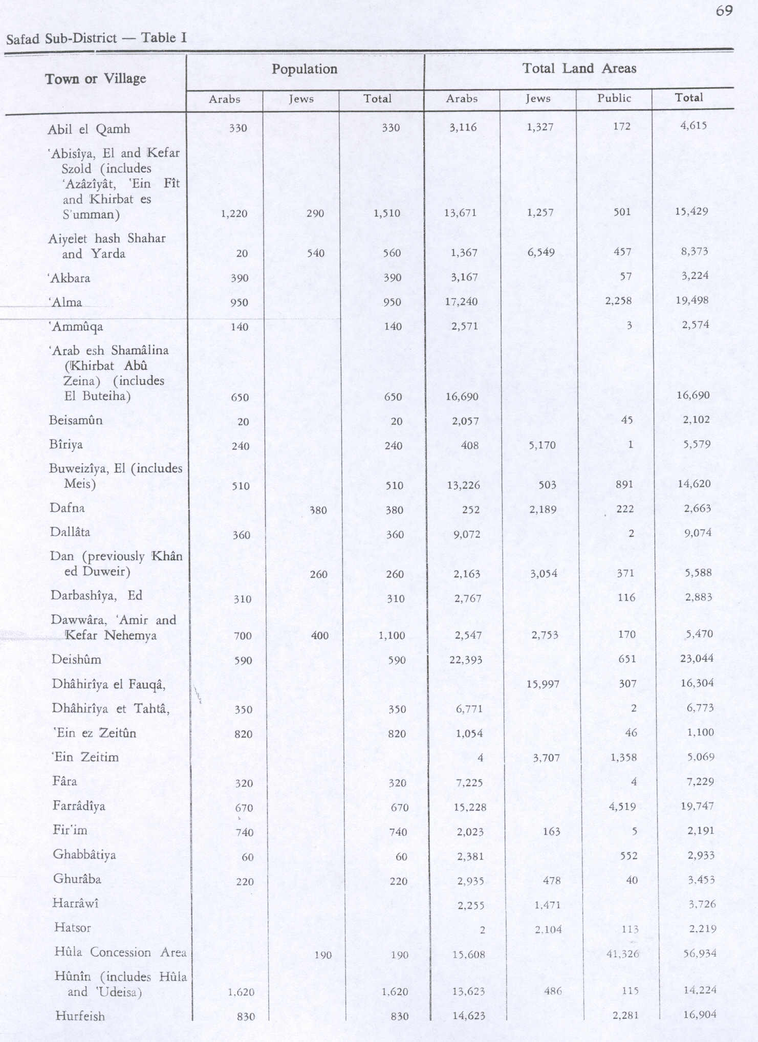
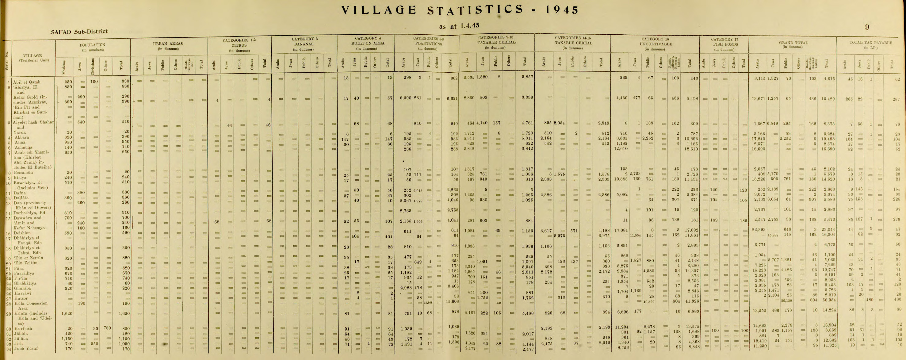
Fir'im (bahasa Arab: فرعم ) adalah sebuah desa Arab Palestina di Subdistrik Safad yang dikosongkan pada Perang Palestina 1948. Desa tersebut mula-mula diserang dalam Perang Saudara Mandat Palestina 1947–1948 pada 2 Mei 1948, oleh Batalion Satu Palmach saat Operasi Yiftach. Pada 1945, populasinya berjumlah 740.
Fir'im
فرعم Feram[1] | |
|---|---|
Desa | |
| Etimologi: dari nama personal[2] | |
  Fir'im | |
| Koordinat: 32°59′07″N 35°31′59″E | |
| Palestine grid | 200/265 |
| Entitas geopolitik | Mandat Palestina |
| Subdistrik | Safad |
| Tanggal pengosongan | 26 Mei 1948[3] |
| Luas | |
| • Total | 2,023 dunams (2,023 km2 or 500 acre) |
| Populasi (1945) | |
| • Total | 740[4][5] |
| Sebab pengosongan | Serangan militer oleh pasukan Yishuv |
| Wilayah saat ini | Hatzor HaGlilit |
Referensi
Daftar pustaka
- Barron, J. B., ed. (1923). Palestine: Report and General Abstracts of the Census of 1922. Government of Palestine.
- Conder, C.R.; Kitchener, H. H. (1881). The Survey of Western Palestine: Memoirs of the Topography, Orography, Hydrography, and Archaeology. 1. London: Committee of the Palestine Exploration Fund.
- Department of Statistics (1945). Village Statistics, April, 1945. Government of Palestine.
- Guérin, V. (1880). Description Géographique Historique et Archéologique de la Palestine (dalam bahasa French). 3: Galilee, pt. 2. Paris: L'Imprimerie Nationale.
- Hadawi, S. (1970). Village Statistics of 1945: A Classification of Land and Area ownership in Palestine. Palestine Liberation Organization Research Centre.
- HaReuveni, Immanuel (1999). Lexicon of the Land of Israel (dalam bahasa Ibrani). Miskal - Yedioth Ahronoth Books and Chemed Books. ISBN 965-448-413-7.
- Hütteroth, Wolf-Dieter; Abdulfattah, Kamal (1977). Historical Geography of Palestine, Transjordan and Southern Syria in the Late 16th Century. Erlanger Geographische Arbeiten, Sonderband 5. Erlangen, Germany: Vorstand der Fränkischen Geographischen Gesellschaft. ISBN 3-920405-41-2.
- Karmon, Y. (1960). "An Analysis of Jacotin's Map of Palestine" (PDF). Israel Exploration Journal. 10 (3,4): 155–173; 244–253. Diarsipkan dari versi asli (PDF) tanggal 2019-12-22. Diakses tanggal 2020-07-10.
- Khalidi, W. (1992). All That Remains:The Palestinian Villages Occupied and Depopulated by Israel in 1948. Washington D.C.: Institute for Palestine Studies. ISBN 0-88728-224-5.
- Mills, E., ed. (1932). Census of Palestine 1931. Population of Villages, Towns and Administrative Areas. Jerusalem: Government of Palestine.
- Morris, B. (2004). The Birth of the Palestinian Refugee Problem Revisited. Cambridge University Press. ISBN 978-0-521-00967-6.
- Palmer, E. H. (1881). The Survey of Western Palestine: Arabic and English Name Lists Collected During the Survey by Lieutenants Conder and Kitchener, R. E. Transliterated and Explained by E.H. Palmer. Committee of the Palestine Exploration Fund.
- Rhode, H. (1979). Administration and Population of the Sancak of Safed in the Sixteenth Century. Columbia University. Diarsipkan dari versi asli tanggal 2019-04-20. Diakses tanggal 2020-07-10.
- Robinson, E.; Smith, E. (1841). Biblical Researches in Palestine, Mount Sinai and Arabia Petraea: A Journal of Travels in the year 1838. 3. Boston: Crocker & Brewster.
- Schumacher, G. (1888). "Population list of the Liwa of Akka". Quarterly statement - Palestine Exploration Fund. 20: 169–191.
Pranala luar
- Welcome To Fir'im
- Fir'im, Zochrot
- Fir’im, Dr. Khalil Rizk.
- Survey of Western Palestine, Map 4: IAA, Wikimedia commons
- Fir'im, at Khalil Sakakini Cultural Center

This article is issued from Wikipedia. The text is licensed under Creative Commons - Attribution - Sharealike. Additional terms may apply for the media files.