Dugi otok
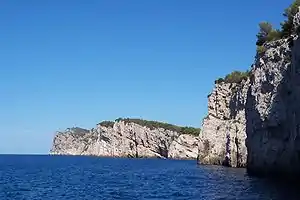
Dugi otok liegt vor Zadar und ist eine Adriainsel vor der kroatischen Küste. Sie hat eine stattliche Länge von 45 km, sie heißt auch übersetzt die (Lange Insel), breit ist sie hingegen nur 1-4,6 km, ihre höchste Erhebung ist der Gipfel Vela Straža (338 m).
 | |
| Dugi otok | |
| Gespanschaft | Zadar |
|---|---|
| Einwohnerzahl | |
| Höhe | 337 m |
| Tourist-Info | www.dugiotok.hr |
 Lagekarte von Kroatien  Dugi otok | |
Orte
- 1 Sali – Hauptort
- 1 Zaglav – Tankstelle für Boote
- 1 Žman
- 1 Luka
- 1 Savar
- 1 Brbinj
- 1 Božava
- 1 Dragove
- 1 Verunić
- 1 Veli Rat
Anreise
Mit den Fähren der G&V Line Iadera ist die Insel via Sali mit Zadar verbunden.
- No. 405 Zadar – Iž – Rava. Zadar - Mali Iz 55 min, Mali Iz - Veli Iz 15 min, Veli Iz - Mala Rava 35 min, Mala Rava - Rava 10 min. Zadar - Radar 2 h 10 min. Mit G&V Line Iadera d.o.o. Geöffnet: 1x tgl. An Sonn- und Feiertagen 2 x, Zadar - Rava 3 x tgl. Preis: In der Hochsaison 4,40 €.
- No. 406 Zadar – (Sali) – Zaglav. Die Fahrzeit beträgt 1h 5 min. Mit G&V Line Iadera d.o.o. Geöffnet: Tgl. Zadar 10:30 - Zaglav an 11:35, Rückfahrt11:45 - Zadar Ankunft 12:50. Preis: In der Hochsaison 4,40 €.
- No. 434 BRBINJ (Dugi otok) - ZADAR/Gaženica. 1 h 40 min Mit Jadrolinija.
- No. 435 - ZADAR/Gaženica - BRŠANJ (Iž) - RAVA - MALA RAVA. Mit Jadrolinija.
- No. 9406 Zadar – (Sali) – Zaglav – Bršanj. Fahrzeit: 45 min. Kein halt bei Sali. Mit G&V Line Iadera d.o.o. Geöffnet: 30.6-3.9 Mo-Sa 3x So zu anderen Zeiten. Preis: In der Hochsaison 6,40 €.
- No. 9405 - ZADAR - MALI IŽ - VELI IŽ - MALA RAVA - RAVA. Mit Jadrolinija.
Sehenswürdigkeiten
Sehenswürdigkeiten
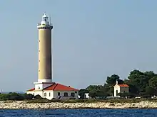
Leuchtturm Veli Rat

- 1 Leuchtturm Veli Rat (Svjetionik Veli rat) . wurde 1849 erbaut und hat eine Höhe von 42 Meter.
- 1 U-Boot-Bunker aus der Zeit der jugoslawischen Volksarmee
- 1 Die Höhle Strašna peć
- 1 Naturpark Telašćica (Telašćica)
- Salzsee Lago Mir
Aktivitäten
- 1 Strand Sekarun
- 1 Panoramablick
Küche
- 1 Konoba Roko Dugi Otok, Zaglav 1, 23281, Zaglav, Kroatien.
- 1 Konoba Martina Zaglav, Zaglav 23, 23281, Zaglav.
- 1 Konoba Regula, Žman 130, 23282, Žman, Kroatien.
- 1 Restaurant Antonio, D124 13, 23285, Brbinj.
- 1 Grill Šjor Bepo, Brbinj.
- 1 Restaurant Boxavia, Božava 1, 23286, Božava.
- 1 Bistro Propela, Božava.
- 1 Konoba Braska, Verunić.
- 1 Galeb, Veli Rat.
- 1 Konoba Lanterna, Veli Rat.
Weblinks


This article is issued from Wikivoyage. The text is licensed under Creative Commons - Attribution - Sharealike. Additional terms may apply for the media files.