Dhami (Mustang)
Dhami (Nepali कागबेनी) ist ein im Distrikt Mustang (Nepal) auf der westlichen Seite des oberen Flusstals des Kali Gandaki gelegenes Village Development Committee (VDC).
| Dhami कागबेनी | |||
|---|---|---|---|
| |||
| Koordinaten | 29° 4′ N, 83° 52′ O | ||
| Basisdaten | |||
| Staat | Nepal | ||
| Gandaki | |||
| Zone | Dhaulagiri | ||
| Distrikt | Mustang | ||
| Einwohner | 611 (2011) | ||
 Kloster bei Ghiling Kloster bei Ghiling | |||


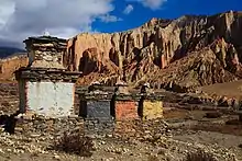
Die Felswände von Dhakmar
Der Hauptort Ghami liegt 35 km nordnordöstlich von Jomsom am Ghami Khola, einem rechten Nebenfluss des Kali Gandaki. Dhami liegt auf der Trekkingroute von Jomsom nach Lo Manthang.
Einwohner
Bei der Volkszählung 2011 hatte Dhami 611 Einwohner (davon 285 männlich) in 169 Haushalten.[1]
Dörfer und Hamlets
Dhami besteht aus mehreren Dörfern und Hamlets:[2]
- Akiama (3540 m)
- Chhunggar (3725 m ⊙)
- Chungsi (3940 m)
- Dhakmar (3786 m ⊙)
- Ghami (3590 m ⊙)
- Ghiling (3500 m ⊙)
- Jhainte (3820 m ⊙)
- Sangboche (3780 m ⊙)
- Tama Gaun (3675 m ⊙)
- Yamda (3870 m)
 Karte mit allen Koordinaten des Abschnitts Dörfer und Hamlets: OSM

Weblinks
Commons: Ghami – Sammlung von Bildern, Videos und Audiodateien

Einzelnachweise
- National Population and Housing Census 2011. (PDF) Central Bureau of Statistics, archiviert vom Original am 31. Juli 2013.
- District: Mustang. List of Settlements. (PDF) (Nicht mehr online verfügbar.) In: Index of Geographical names of Nepal. National Geographic Information Infrastructure Programme. www.ngiip.gov.np, archiviert vom Original am 6. Februar 2016; abgerufen am 15. April 2014.
This article is issued from Wikipedia. The text is licensed under Creative Commons - Attribution - Sharealike. Additional terms may apply for the media files.