Urnieta
Urnieta ist eine Stadt in der Provinz Gipuzkoa im spanischen Baskenland. Sie hat 6168 Einwohner (Stand 1. Januar 2019).
| Gemeinde Urnieta | |||
|---|---|---|---|
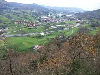 | |||
| Wappen | Karte von Spanien | ||
.svg.png.webp) |
| ||
| Basisdaten | |||
| Land: |  Spanien Spanien | ||
| Autonome Gemeinschaft: |  Baskenland Baskenland | ||
| Provinz: | Gipuzkoa | ||
| Comarca: | Donostialdea | ||
| Koordinaten | 43° 15′ N, 2° 0′ W | ||
| Fläche: | 22,40 km² | ||
| Einwohner: | 6.168 (1. Jan. 2019)[1] | ||
| Bevölkerungsdichte: | 275 Einw./km² | ||
| Postleitzahl(en): | 20130 | ||
| Gemeindenummer (INE): | 20072 | ||
| Verwaltung | |||
| Bürgermeister: | Jorge Segurado | ||
| Website: | www.urnieta.eus/eu/ | ||
| Lage des Ortes | |||
Karte anzeigen  | |||

.svg.png.webp)
Geografie
Die Gemeinde grenzt an die Gemeinden Andoain, Elduain, Hernani und Lasarte-Oria.
Bevölkerungsentwicklung
| Jahr | Einwohner |
|---|---|
| 1842 | 1107 |
| 1900 | 2058 |
| 1950 | 2597 |
| 2001 | 5518 |
| 2011 | 6191 |
Sehenswürdigkeiten
- Pfarrkirche zu San Miguel Arcángel
- Höhle von Marizulo
Weblinks

- Offizielle Website von Urnieta (baskisch, spanisch)
Einzelnachweise
- Cifras oficiales de población resultantes de la revisión del Padrón municipal a 1 de enero. Bevölkerungsstatistiken des Instituto Nacional de Estadística (Bevölkerungsfortschreibung).

Abaltzisketa | Aduna | Aia | Aizarnazabal | Albiztur | Alegia | Alkiza | Altzaga | Altzo | Amezketa | Andoain | Anoeta | Antzuola | Arama | Aretxabaleta | Arrasate (Mondragón) | Asteasu | Astigarraga | Ataun | Azkoitia | Azpeitia | Baliarrain | Beasain | Beizama | Belauntza | Berastegi | Bergara | Berrobi | Bidania-Goiatz | Deba | Donostia-San Sebastián | Eibar | Elduain | Elgeta | Elgoibar | Errenteria | Errezil | Eskoriatza | Ezkio-Itsaso | Gabiria | Gaintza | Gaztelu | Getaria | Hernani | Hernialde | Hondarribia | Ibarra | Idiazábal | Ikaztegieta | Irun | Irura | Itsasondo | Larraul | Lasarte-Oria | Lazkao | Leaburu | Legazpi | Legorreta | Leintz-Gatzaga | Lezo | Lizartza | Mendaro | Mutiloa | Mutriku | Oiartzun | Olaberria | Oñati | Ordizia | Orendain | Orexa | Orio | Ormaiztegi | Pasaia | Segura (Baskenland) | Soraluze-Placencia de las Armas | Tolosa | Urnieta | Urretxu | Usurbil | Villabona | Zaldibia | Zarautz | Zegama | Zerain | Zestoa | Zizurkil | Zumaia | Zumarraga