Pasacao
Pasacao, officially the Municipality of Pasacao (Central Bikol: Banwaan kan Pasacao; Tagalog: Bayan ng Pasacao), is a 2nd class municipality in the province of Camarines Sur, Philippines. According to the 2020 census, it has a population of 53,461 people. [3]
Pasacao | |
|---|---|
| Municipality of Pasacao | |
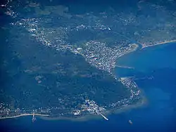 Aerial shot of Pasacao with its port and oil depot. | |
 Seal | |
| Nickname: Summer Capital of Camarines Sur | |
| Motto: Matatag na Bayan ng Pasacao[lower-alpha 1] | |
 Map of Camarines Sur with Pasacao highlighted | |
OpenStreetMap  | |
.svg.png.webp)  Pasacao Location within the Philippines | |
| Coordinates: 13°30′37″N 123°02′31″E | |
| Country | Philippines |
| Region | Bicol Region |
| Province | Camarines Sur |
| District | 2nd district |
| Founded | 1872 |
| Barangays | 19 (see Barangays) |
| Government | |
| • Type | Sangguniang Bayan |
| • Mayor | Jorge R. Bengua |
| • Vice Mayor | Maryol O. Tayco |
| • Representative | Luis Raymund F. Villafuerte Jr. |
| • Municipal Council | Members |
| • Electorate | 31,618 voters (2022) |
| Area | |
| • Total | 149.54 km2 (57.74 sq mi) |
| Elevation | 36 m (118 ft) |
| Highest elevation | 756 m (2,480 ft) |
| Lowest elevation | 0 m (0 ft) |
| Population | |
| • Total | 53,461 |
| • Density | 360/km2 (930/sq mi) |
| • Households | 11,971 |
| Demonym | Pasaqueño (Masculine) Pasaqueña (Feminine) |
| Economy | |
| • Income class | 1st municipal income class |
| • Poverty incidence | 41.62% (2015)[4] |
| • Revenue | ₱197,378,822.82 |
| • Assets | ₱ 528.4 million (2020) |
| • Expenditure | ₱ 137.2 million (2020) |
| • Liabilities | ₱ 168.3 million (2020) |
| Service provider | |
| • Electricity | Camarines Sur 1 Electric Cooperative (CASURECO 1) |
| • Water | Pasacao Water District (PAWADI) |
| Time zone | UTC+8 (PST) |
| ZIP code | 4417 |
| PSGC | |
| IDD : area code | +63 (0)54 |
| Native languages | Central Bikol Tagalog |
| Major religions | Roman Catholicism |
| Feast date | August 30 |
| Catholic diocese | Roman Catholic Diocese of Libmanan |
| Patron saint | Saint Rose of Lima |
| Website | pasacao |
It is known for its long stretch of brownish sand beaches, earning it the title "Summer Capital of Camarines Sur".[5] The municipality has jurisdiction over the 200-m tall Daruanak island, which is the town's unofficial symbol and appears on its official seal.
The Port of Pasacao, located in Barangay Sta. Rosa Del Sur, is a fishing, passenger, cargo port and serves passengers traveling from Pasacao to Burias in Masbate.
During the Spanish colonization in the 16th century, Pasacao was one of the embarkation points in Camarines Sur and was the only sea transportation link to Manila. It played a vital role in the development of commerce and trade in the province.[6]
The town was formed in 1872, according to records from the Archdiocese of Cáceres.[6]
Etymology
The town's name is derived from the Spanish-Tagalog portmanteau Pasa-Ikaw (English: Pass it on). This is because dock guards stationed at the Pasacao Port would regularly issue directions to passengers by shouting "Pasa ikaw, Pasa ikaw." Passengers mistook the phrase for the town's name, Pasacao.[6]
History
Moro piracy
From 1585 to the 19th century, Pasacao served as a crucial defense port against Moro pirate incursions. The continuing Moro piracy, such as the one in Caranan on October 4, 1779, is an example. Pasacao and other 9 towns and two missions were entirely destroyed; ten churches were robbed and torched; 8,000 indigenous people were captured or slain; one priest was killed, two were captured; and Caceres, the capital, was placed on high alert one night.[7] In 1823, the town had an estimated population of only 200 people due to frequent attacks.[6]
As defense of Pasacao against these raids, Alcalde Jacinto Rodriguez Morales contributed material for a balwark. He also gave watchmen rations. The fortification of Pasacao in 1848, which included Cabusao in Camarines Sur, Pantao (now Libon), and Donsol in Sorsogon, was motivated by these persistent moro invasions.[6]
Post-colonization
Between 1609 and 1616, during the governor generalship of Juan de Silva, two galleons, the Nuestra Seora de Guadalupe and Angel dela Guardia, were built in Barangay Dalupaon, as well as the Astillero de Dalupaon (English: Dalupaon Shipyard). Guadalupe was vital in the galleon commerce between Manila and Acapulco, as well as the defense of the Philippines against the Dutch at the Battle of Playa Honda.[6]
When World War II broke out on December 8, 1941, Juan Q. Miranda and Elias Madrid, both from Canaman and Leon Sa. Aureus from Libmanan founded the Tangcong Vaca Guerilla Unit. It was the province's first big guerilla unit, established on March 18, 1942. The TVGU takes its name from Mount Bernacci, where they set up camp. Miranda commanded 67 men from multiple guerilla squads in a two-and-a-half-hour convoy ambush near Taguild, Pamplona, on November 8, 1942. Colonel Susumo Takechi (the Japanese commander in Naga), two captains, two lieutenants, and 168 to 200 enlisted men were all slain.[8] Other significant historical events in Pasacao also left their mark. When the Japanese ships docked at the Pasacao Pier, it was bombed. Until today, some Japanese ships have been visible in clear waters.[6]
In 1945, American Taylorcraft L-2 Grasshopper planes landed in Tinalmud, bringing The Six Daughters of Charity to the Pasacao seashore to establish Naga City's first regular girls' school, Universidad de Santa Isabel.[6]
Geography
Pasacao is situated on the northwest coast of the Camarines Sur, and bounded by Mount Bernacci, it shares a border with Libmanan in the northwest, San Fernando in the east, Pamplona in the north. The terrain in Pasacao is mostly hilly, especially in the west. The plains and the seasides of the region are where the majority of people live.
Barangays
Pasacao is politically subdivided into 19 barangays.
| Barangays[9] | Population (2020) | Feast Date | Political Zones | |
|---|---|---|---|---|
| Antipolo | 1.78% | 953 | May 24 | 6 |
| Bagong Silang | 1.03% | 550 | April 28 | 7 |
| Bahay | 3.56% | 1,905 | October 25 | 6 |
| Balogo | 10.82% | 5,785 | July 16 | 7 |
| Caranan | 19.57% | 10,460 | June 13 | 14 |
| Cuco | 3.75% | 2,004 | October 15 | 7 |
| Dalupaon | 7.44% | 3,977 | June 24 | 14 |
| Hubo | 1.46% | 780 | May 22 | 7 |
| Itulan | 2.29% | 1,226 | October 4 | 5 |
| Macad[lower-alpha 2] | 3.41% | 1,823 | February 11 | 7 |
| Odicon | 5.69% | 3,043 | May 16 | 7 |
| Quitang | 5.59% | 2,991 | July 25 | 7 |
| Salvacion | 1.86% | 995 | April 25 | — |
| San Antonio | 1.15% | 613 | May 12 | 7 |
| San Cirilo | 9.97% | 5,53 | May 1 | 8 |
| Santa Rosa Del Norte | 7.74% | 4,136 | October 24 | 8 |
| Santa Rosa Del Sur | 6.60% | 3,527 | January 19 | 7 |
| Tilnac | 1.73% | 927 | January 28 | 7 |
| Tinalmud | 4.55% | 2,435 | — | — |
| Total | 100% | 53,461 | ||
Climate
| Climate data for Pasacao | |||||||||||||
|---|---|---|---|---|---|---|---|---|---|---|---|---|---|
| Month | Jan | Feb | Mar | Apr | May | Jun | Jul | Aug | Sep | Oct | Nov | Dec | Year |
| Mean maximum °F (°C) | 82 (28) |
84 (29) |
86 (30) |
88 (31) |
90 (32) |
90 (32) |
86 (30) |
88 (31) |
88 (31) |
86 (30) |
84 (29) |
84 (29) |
90 (32) |
| Mean minimum °F (°C) | 75 (24) |
73 (23) |
75 (24) |
75 (24) |
79 (26) |
79 (26) |
79 (26) |
79 (26) |
77 (25) |
77 (25) |
77 (25) |
77 (25) |
73 (23) |
| Average precipitation inches (mm) | 5.82 (147.9) |
3.56 (90.5) |
3.06 (77.8) |
3.08 (78.2) |
5.66 (143.8) |
8.31 (211.1) |
12.46 (316.4) |
10.05 (255.3) |
11.96 (303.9) |
10.10 (256.6) |
5.81 (147.7) |
8.85 (224.7) |
88.72 (2,253.9) |
| Average rainy days | 6 | 4 | 5 | 4 | 9 | 12 | 18 | 13 | 14 | 11 | 7 | 8 | 111 |
| Average ultraviolet index | 6 | 6 | 6 | 7 | 7 | 6 | 6 | 6 | 6 | 6 | 6 | 6 | 6 |
| Source: World Weather Online[10] | |||||||||||||
According to the Köppen climate classification system, Pasacao has a tropical rainforest climate. The north-east monsoon dominates the area, therefore rainfall is evenly spread throughout the year. From October to January, the wind blows from north to east, from east to southeast from February to April, and from May to September, it blows from east to southeast. From December to May, the area is rather dry, and the rest of the year is wet.
The Philippines, particularly especially Pasacao, experience a hot and dry season from February to May. Most visitors and tourists come to Pasacao to relax during these months. Most resorts and beaches are packed with people on Easter Sunday, especially from local communities and other parts of the country.
Demographics
In the 2020 census, the population of Pasacao was 53,461 people, [3] with a density of 360 inhabitants per square kilometre or 930 inhabitants per square mile.
| Year | Pop. | ±% p.a. |
|---|---|---|
| 1903 | 2,431 | — |
| 1918 | 2,308 | −0.35% |
| 1939 | 5,594 | +4.31% |
| 1948 | 8,128 | +4.24% |
| 1960 | 14,327 | +4.84% |
| 1970 | 19,355 | +3.05% |
| 1975 | 21,809 | +2.42% |
| 1980 | 25,303 | +3.02% |
| 1990 | 31,960 | +2.36% |
| 1995 | 36,070 | +2.29% |
| 2000 | 38,423 | +1.36% |
| 2007 | 41,533 | +1.08% |
| 2010 | 45,946 | +3.74% |
| 2015 | 49,035 | +1.25% |
| 2020 | 53,461 | +1.71% |
| Source: Philippine Statistics Authority [11] [12] [13][14] | ||
Language
Despite the fact that Tagalog is the Philippines' national language and English is widely known in the corporate world, these languages are rarely used in Pasacao. The majority of the inhabitants speak Central Bikol.
Religion
Despite the fact that the municipality only has one church, Saint Rose of Lima Parish, and a few chapels, Roman Catholicism is the predominant religion. Iglesia ni Kristo also has various chapels throughout the municipality's barangays.
Economy
Fishing, farming, and retail are the main sources of income for the majority of the locals. Many schools and a growing number of local businesses give additional work opportunities for people. Other locals work at the oil depots in Barangay Sta. Rosa Del Sur (the area is also claimed by Barangay Caranan), as well as some labor in Naga and the Metropolitan Manila area.
Culture
Town Fiesta and Pasa-Pasa Ikaw Festival
Every year on August 29–30, the town holds its town fiesta and the Pasa-Pasa Ikaw Festival. The fiesta is commemorated in honor of the town's patroness, St. Rose of Lima, by holding a program of events that includes annual pageant competitions, civic and military parades, and others.
Daruanak Summer Festival
TBE
Attractions
Signature Park
Signature[lower-alpha 3] Park is an 1,145-square-meter reclaimed property owned by the Local Government of Pasacao located in Barangay Sta. Rosa Del Norte. It serves as a recreational park and is also the location of several government offices. StrEat Park, Central Business District Terminal, a covered court, an eco-park, a plaza, and a grandstand are some of the buildings in the park. Construction of a two-story PNP building is also ongoing. The park intended to serve as the center of government, but the major offices have not yet been built.
Pasacao Boulevard
TBE
Infrastructure
Pasacao-Balatan Tourism Coastal Highway
The Pasacao-Balatan Tourism Coastal Highway is a 40.69-kilometer project of the National Economic and Development Authority (NEDA) and the Build, Build, Build program. It connects the municipalities of Pasacao, San Fernando, Minalabac, Bula, and Balatan, as well as 15 additional barangays, with the goal of promoting ecotourism in Camarines Sur. There are 13 bridges in the network of roads, as well as intersections, service roads, and other infrastructure.[22]
Education
In addition to the already existing public secondary schools, private schools, and public elementary schools (which every baranggay has), Pasacao is also home to the Camarines Sur Institute of Marine Sciences (CASIFMAS), a vocational school and a satellite campus of the Central Bicol State University for Agriculture (CBSUA), which houses a faculty for the College of Education.
Here's the list of the tertiary and secondary level existing schools on the municipality.
- Tertiary
- Camarines Sur Institute of Fisheries and Marine Sciences (CASIFMAS)
- Camarines Sur Institute of Fisheries and Marine Sciences (CASIFMAS) - Caranan Campus
- Central Bicol State University for Agriculture (CBSUA) - Pasacao Extension Campus
- Secondary
- Antipolo Heights Integrated School - Zone 3, Antipolo, Pasacao
- Arbovitae Plains Montessori Inc. (APMI) - Pasacao Branch - Acacia Drive, Santa Rosa Del Norte, Pasacao
- Balogo Baptist Christian School, Inc.
- Dalupaon National High School
- Dr. Lorenzo P. Ziga Memorial High School - Balogo, Pasacao
- Juan F. Triviño Memorial High School - Caranan, Pasacao
- La Florianne Institute of Learning, Inc. - Santa Rosa Del Norte, Pasacao
- Lyceo de Pasacao - Santa Rosa Del Norte, Pasacao
- Pasacao Academy - Santa Rosa Del Norte, Pasacao
- Pasacao Municipal High School - Santa Rosa Del Norte, Pasacao
- Rolando R. Andaya Memorial High School - Bahay, Pasacao
Gallery
 Daruanak Island
 Pasacao Port
Notes
-
- Malinig (English: Clean)
- Asensado (English: Prosperous)
- Trangkilo (English: Peaceful)
- Areglado (English: Organized)
- Tarabangan para sa aktibong pag gobernar (English: Cooperated for an active governance)
- Formerly Hebrio Lourdes
- Seat of Inclusive Governance
References
- Municipality of Pasacao | (DILG)
- "2015 Census of Population, Report No. 3 – Population, Land Area, and Population Density" (PDF). Philippine Statistics Authority. Quezon City, Philippines. August 2016. ISSN 0117-1453. Archived (PDF) from the original on May 25, 2021. Retrieved July 16, 2021.
- Census of Population (2020). "Region V (Bicol Region)". Total Population by Province, City, Municipality and Barangay. PSA. Retrieved 8 July 2021.
- "PSA releases the 2015 Municipal and City Level Poverty Estimates". Quezon City, Philippines. Retrieved 1 January 2020.
- Barrameda, Shiena M. (2013-06-12). "Saving Pasacao as summer capital". INQUIRER.net. Retrieved 2022-05-15.
- "History of Pasacao | LGU Pasacao Official Website". Retrieved 2022-05-13.
- Abella, Domingo (1954). Bikol annals: A Collection of Vignettes of Philippine History.. Manila.
- Barrameda. pp. 43–44.
- "Barangays | LGU Pasacao Official Website". Retrieved 2022-05-15.
- "Pasacao Climate Weather Averages". Retrieved May 13, 2022.
- Census of Population (2015). "Region V (Bicol Region)". Total Population by Province, City, Municipality and Barangay. PSA. Retrieved 20 June 2016.
- Census of Population and Housing (2010). "Region V (Bicol Region)". Total Population by Province, City, Municipality and Barangay. NSO. Retrieved 29 June 2016.
- Censuses of Population (1903–2007). "Region V (Bicol Region)". Table 1. Population Enumerated in Various Censuses by Province/Highly Urbanized City: 1903 to 2007. NSO.
- "Province of Camarines Sur". Municipality Population Data. Local Water Utilities Administration Research Division. Retrieved 17 December 2016.
- "Poverty incidence (PI):". Philippine Statistics Authority. Retrieved 28 December 2020.
- https://psa.gov.ph/sites/default/files/NSCB_LocalPovertyPhilippines_0.pdf; publication date: 29 November 2005; publisher: Philippine Statistics Authority.
- https://psa.gov.ph/sites/default/files/2003%20SAE%20of%20poverty%20%28Full%20Report%29_1.pdf; publication date: 23 March 2009; publisher: Philippine Statistics Authority.
- https://psa.gov.ph/sites/default/files/2006%20and%202009%20City%20and%20Municipal%20Level%20Poverty%20Estimates_0_1.pdf; publication date: 3 August 2012; publisher: Philippine Statistics Authority.
- https://psa.gov.ph/sites/default/files/2012%20Municipal%20and%20City%20Level%20Poverty%20Estima7tes%20Publication%20%281%29.pdf; publication date: 31 May 2016; publisher: Philippine Statistics Authority.
- https://psa.gov.ph/sites/default/files/City%20and%20Municipal-level%20Small%20Area%20Poverty%20Estimates_%202009%2C%202012%20and%202015_0.xlsx; publication date: 10 July 2019; publisher: Philippine Statistics Authority.
- "PSA Releases the 2018 Municipal and City Level Poverty Estimates". Philippine Statistics Authority. 15 December 2021. Retrieved 22 January 2022.
- "Groundworks for Pasacao-Balatan Tourism Coastal Highway now underway". ph.news.yahoo.com. Retrieved 2022-12-27.
External links

- Official Website of Pasacao, Camarines Sur
- Philippine Standard Geographic Code
- Philippine Census Information
- Official Site of the Province of Camarines Sur
- Barangays of Pasacao, Camarines Sur
Places adjacent to Pasacao | ||||||||||||||||
|---|---|---|---|---|---|---|---|---|---|---|---|---|---|---|---|---|
| ||||||||||||||||


Statistically grouped with the Province of Camarines Sur | |||||||
| Administrative divisions |
|  | |||||
| Geography | |||||||
| History | |||||||
| Religion | |||||||
| Public utilities and services |
| ||||||
| Transportation |
| ||||||
| Education |
| ||||||
| Landmarks | |||||||
| |||||||
 Province of Camarines Sur Province of Camarines Sur | |
|---|---|
| Municipalities | |
| Component city | |
| Independent component city |
|
