Pelican Butte
Pelican Butte is a steep-sided dormant shield volcano in the Cascade Range of southern Oregon. It is located 28 miles (45 km) due south of Crater Lake and 12 miles (19 km) northeast of Mount McLoughlin, and rises over 3,800 feet (1,200 m) directly above the shore of Upper Klamath Lake. Ice age glaciers carved a large cirque into the northeast flank of the mountain, forming a steep bowl which is popular in winter with backcountry skiers and snowmobilers. Several proposals have been made over the last few decades for ski area development on the northeast flanks, but none of the proposals has obtained the regulatory approval from the United States Forest Service necessary to proceed with construction. If the ski area is ever built, its skiable vertical of over 3,800 feet (1,200 m) would be the largest in Oregon exceeding the 3,590 feet (1,090 m) of Timberline Lodge ski area on Mount Hood.
| Pelican Butte | |
|---|---|
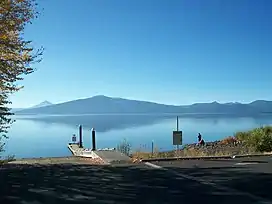 Pelican Butte from across Agency Lake | |
| Highest point | |
| Elevation | 8,037 ft (2,450 m) NAVD 88[1] |
| Prominence | 2,196 ft (669 m)[2] |
| Coordinates | 42°30′48″N 122°08′43″W[1] |
| Geography | |
| Location | Klamath County, Oregon, U.S. |
| Parent range | Cascades |
| Topo map | USGS Pelican Butte |
| Geology | |
| Mountain type | Shield volcano |
| Volcanic arc | Cascade Volcanic Arc |
| Last eruption | Less than 300,000 years ago[3] |
| Climbing | |
| Easiest route | Dirt road |
The land is in the Fremont-Winema National Forest and a Forest Service fire lookout tower was built on the summit in 1935, and upgraded several times over the ensuing decades. It was replaced in 1986 with a modern 40-foot (12 m) steel tower, which remains to this day and is festooned with a large array of microwave and radio antennas. A 5-mile (8.0 km) long dirt road zigzags up the west flanks of the volcano to the summit.
Geography
Pelican Butte is located in Klamath County, Oregon.[4] It is disconnected from the main axis of the Cascade Range, having formed above a network of normal faults that mark the eastern border of the Cascades.[5]
Pelican Butte has steep sides and despite erosion from glaciers, its original shape is mostly preserved. During the Pleistocene epoch, glaciers formed a canyon and a cirque on the northeastern side of the volcano; they also reduced the summit elevation several tens of meters and carved out an intrusive conduit in the volcano. Pelican Butte is large, with a volume of 4.8 cubic miles (20 km3), making it one of the larger Quaternary volcanoes in the region of Crater Lake and Mount Shasta. It is about 33 percent larger than Mount McLoughlin,[6] which lies to its west.[7] Pelican Butte is the most prominent shield volcano in the southern Oregon Cascades.[7]
Geology
Pelican Butte is a shield volcano. It sits on basaltic andesite erupted during the Pliocene and early Pleistocene epochs. Samples from the volcano have 58 to 60 percent silica, and the volcano is made up of calc-alkaline basaltic andesite and andesite lava with normal polarity. For the lower volcano, thick lava flows followed existing channels forming glassy deposits with phenocrysts including plagioclase, augite, hypersthene, and olivine. These phenocrysts are relatively sparse among the lava flows.[6] A second type of andesitic lava created thinner flows with blocks and scoria closer to the summit of the volcano. With a finer grain and vesicular texture, the lava has phenocrysts of white plagioclase with sodic labradorite as well as olivine, augite, and hypersthene.[6] It is believed that the volcano is made up of breccia based on eroded areas with breccia between lava flows, though breccia is not well-exposed elsewhere on the mountain.[6] The summit of Pelican Butte has a cinder cone.[7]
Pelican Butte last erupted within the past 700,000 years.[6] Dating for its last eruptive activity is unclear; it has clearly not erupted since it was covered by glaciers about 12,000 years ago, though it probably has not erupted for 60,000 years. According to Wood and Kienle (1990), most eruptions took place less than 200,000 years ago.[5] The volcano built a summit cone with tuff breccia and lapilli during pyroclastic eruptive activity,[8] which was mostly covered by lava flows before it was eroded over time[5] by glaciation, which lowered the cone's elevation significantly. Eruptive activity at Pelican Butte was mildly explosive, later switching to thinner flows with ʻaʻā and block lava.[9]
A fault scarp sits adjacent to lava flows on the western flank of the volcano, though the fault did not move the deposits, suggesting this lava was erupted 1.17 million years ago.[5]
Human history
Pelican Butte is named after nearby Pelican Bay. It was also known by American Indians as Mongina; the U.S. Coast and Geodetic Survey previously listed it under the name Lost Peak.[4]
Recreation
A gravel road runs all the way to the summit of the mountain, branching north off Oregon Route 140. The road is only open during snow-free months during the summer. The last few miles of the road are steep and narrow, but they are accessible by vehicles with high ground clearance. The peak of Pelican Butte offers a 180 degree view of the Cascades stretching from south of Crater Lake to Mount McLoughlin.[5]
References
- "Pelican". NGS Data Sheet. National Geodetic Survey, National Oceanic and Atmospheric Administration, United States Department of Commerce. Retrieved 2008-04-01.
- "Pelican Butte, Oregon". Peakbagger.com. Retrieved 2008-04-01.
- "Deschutes & Ochoco National Forests - Pelican Butte Volcano". US Forest Service. Archived from the original on 2011-05-12. Retrieved 2008-04-01.
- McArthur & McArthur 1992, p. 658.
- Wood & Kienle 1990, p. 196.
- Wood & Kienle 1990, p. 195.
- Harris 2005, p. 131.
- Wood & Kienle 1990, p. 195–96.
- Harris 2005, p. 132.
Sources
- Gorman, C. (April 1, 1994). Petrology and geochemistry of the Pelican Butte area, S. Oregon. North-Central Section of the Geological Society of America. Geological Society of America. pp. 137–140. OSTI 7141004.
- Harris, Stephen L. (2005). Fire Mountains of the West: The Cascade and Mono Lake Volcanoes (3rd ed.). Mountain Press Publishing Company. ISBN 0-87842-511-X.
- Wood, Charles A.; Kienle, Jürgen, eds. (1990). Volcanoes of North America. Cambridge University Press. ISBN 0-521-43811-X.
- Kresek, Ray (1998). Fire Lookouts of the Northwest (3rd ed.). Historic Lookout Project. ISBN 0-87770-632-8.
- McArthur, L. A.; McArthur, L. L. (1992) [1928]. Oregon Geographic Names (6th ed.). Portland, Oregon: Oregon Historical Society Press. ISBN 978-0-87595-237-6.