Portal:Morocco

The Morocco Portal

Morocco (/məˈrɒk/ (listen)), officially the Kingdom of Morocco, is a country in the Maghreb region of North Africa. It overlooks the Mediterranean Sea to the north and the Atlantic Ocean to the west, and has land borders with Algeria to the east, and the disputed territory of Western Sahara to the south. Mauritania lies to the south of Western Sahara. Morocco also claims the Spanish exclaves of Ceuta, Melilla and Peñón de Vélez de la Gomera, and several small Spanish-controlled islands off its coast. It spans an area of 446,300 km2 (172,300 sq mi) or 710,850 km2 (274,460 sq mi),[b] with a population of roughly 37 million. Its official and predominant religion is Islam, and the official languages are Arabic and Berber; the Moroccan dialect of Arabic and French are also widely spoken. Moroccan identity and culture is a mix of Arab, Berber, and European cultures. Its capital is Rabat, while its largest city is Casablanca.

In a region inhabited since the Paleolithic Era over 300,000 years ago, the first Moroccan state was established by Idris I in 788. It was subsequently ruled by a series of independent dynasties, reaching its zenith as a regional power in the 11th and 12th centuries, under the Almoravid and Almohad dynasties, when it controlled most of the Iberian Peninsula and the Maghreb. In the 15th and 16th centuries, Morocco faced external threats to its sovereignty, with Portugal seizing some territory and the Ottoman Empire encroaching from the east. The Marinid and Saadi dynasties otherwise resisted foreign domination, and Morocco was the only North African nation to escape Ottoman dominion. The 'Alawi dynasty, which rules the country to this day, seized power in 1631, and over the next two centuries expanded diplomatic and commercial relations with the Western world. Morocco's strategic location near the mouth of the Mediterranean drew renewed European interest; in 1912, France and Spain divided the country into respective protectorates, reserving an international zone in Tangier. Following intermittent riots and revolts against colonial rule, in 1956, Morocco regained its independence and reunified.

Since independence, Morocco has remained relatively stable. It has the fifth-largest economy in Africa and wields significant influence in both Africa and the Arab world; it is considered a middle power in global affairs and holds membership in the Arab League, the Union for the Mediterranean, and the African Union. Morocco is a unitary semi-constitutional monarchy with an elected parliament. The executive branch is led by the King of Morocco and the prime minister, while legislative power is vested in the two chambers of parliament: the House of Representatives and the House of Councillors. Judicial power rests with the Constitutional Court, which may review the validity of laws, elections, and referendums. The king holds vast executive and legislative powers, especially over the military, foreign policy and religious affairs; he can issue decrees called dahirs, which have the force of law, and can also dissolve the parliament after consulting the prime minister and the president of the constitutional court.

Morocco claims ownership of the non-self-governing territory of Western Sahara, which it has designated its Southern Provinces. In 1975, after Spain agreed to decolonise the territory and cede its control to Morocco and Mauritania, a guerrilla war broke out between those powers and some of the local inhabitants. In 1979, Mauritania relinquished its claim to the area, but the war continued to rage. In 1991, a ceasefire agreement was reached, but the issue of sovereignty remained unresolved. Today, Morocco occupies two-thirds of the territory, and efforts to resolve the dispute have thus far failed to break the political deadlock. (Full article...)

Selected article -

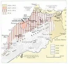
Map showing the area in which the war was fought.

The Zaian (or Zayan) War was fought between France and the Zaian Confederation of Berber tribes in Morocco between 1914 and 1921 during the French conquest of Morocco. Morocco had become a French protectorate in 1912, and Resident-General Louis-Hubert Lyautey sought to extend French influence eastwards through the Middle Atlas mountains towards French Algeria. This was opposed by the Zaians, led by Mouha ou Hammou Zayani. The war began well for the French, who quickly took the key towns of Taza and Khénifra. Despite the loss of their base at Khénifra, the Zaians inflicted heavy losses on the French, who responded by establishing groupes mobiles, combined arms formations that mixed regular and irregular infantry, cavalry and artillery into a single force.

The outbreak of the First World War proved significant, with the withdrawal of troops for service in France compounded by the loss of more than 600 French killed at the Battle of El Herri. Lyautey reorganised his available forces into a "living barricade", consisting of outposts manned by his best troops protecting the perimeter of French territory with lower quality troops manning the rear-guard positions. Over the next four years the French retained most of their territory despite intelligence and financial support provided by the Central Powers to the Zaian Confederation and continual raids and skirmishes reducing scarce French manpower.

After the signing of the Armistice with Germany in November 1918, significant forces of tribesmen remained opposed to French rule. The French resumed their offensive in the Khénifra area in 1920, establishing a series of blockhouses to limit the Zaians' freedom of movement. They opened negotiations with Hammou's sons, persuading three of them, along with many of their followers, to submit to French rule. A split in the Zaian Confederation between those who supported submission and those still opposed led to infighting and the death of Hammou in Spring 1921. The French responded with a strong, three-pronged attack into the Middle Atlas that pacified the area. Some tribesmen, led by Moha ou Said, fled to the High Atlas and continued a guerrilla war against the French well into the 1930s. (Full article...)
List of selected articles

General images -

The following are images from various Morocco-related articles on Wikipedia.

Categories

Category puzzle
Select [►] to view subcategories
Morocco
Morocco-related lists
Buildings and structures in Morocco
Moroccan culture
Economy of Morocco
Education in Morocco
Environment of Morocco
Geography of Morocco
Government of Morocco
Health in Morocco
History of Morocco
Organizations based in Morocco
Moroccan people
Politics of Morocco
Society of Morocco
Morocco stubs

Moroccan History


Wikiprojects

WikiProject Morocco

WikiProject Africa

Good article -

This is a Good article, an article that meets a core set of high editorial standards.

Bombardment of Salé by Jean Antoine Théodore de Gudin

The Bombardment of Salé was a French naval attack against the Moroccan city of Salé that took place between 26 and 27 November 1851. After seven hours of fighting, the Moroccan artillery suffered severe damage, and the French bombarded the city through the night, damaging the city's infrastructure and the Great Mosque of Salé.

During seven hours of clashes, the Moroccan artillery of Salé supported by that of Rabat and led by the Abdelhadi Zniber suffered significant damage. The French squadron commanded by Rear Admiral Louis Dubourdieu bombarded the city until the next day, seriously damaging the city's infrastructure, including the Great Mosque which was seriously affected. (Full article...)

Did you know -

Moroccan cities

Rank City Population
(2014 census)[1][2]
Region
1Casablanca[lower-alpha 1]3,359,818Casablanca-Settat
2Fez[lower-alpha 2]1,112,072Fès-Meknès
3Tangier[lower-alpha 3]947,952Tanger-Tetouan-Al Hoceima
4Marrakesh[lower-alpha 4]928,850Marrakesh-Safi
5Salé[lower-alpha 5]890,403Rabat-Salé-Kénitra
6Meknes[lower-alpha 6]632,079Fès-Meknès
7Rabat[lower-alpha 7]577,827Rabat-Salé-Kénitra
8Oujda494,252Oriental
9Kenitra431,282Rabat-Salé-Kénitra
10Agadir421,844Souss-Massa
11Tetouan380,787Tanger-Tetouan-Al Hoceima
12Temara313,510Rabat-Salé-Kénitra
13Safi308,508Marrakesh-Safi
14Mohammedia208,612Casablanca-Settat
15Khouribga196,196Béni Mellal-Khénifra
16El Jadida194,934Casablanca-Settat
17Beni Mellal192,676Béni Mellal-Khénifra
18Aït Melloul171,847Souss-Massa
19Nador161,726Oriental
20Dar Bouazza151,373Casablanca-Settat
21Taza148,456Fès-Meknès
22Settat142,250Casablanca-Settat
23Berrechid136,634Casablanca-Settat
24Khemisset131,542Rabat-Salé-Kénitra
25Inezgane130,333Souss-Massa
26Ksar El Kebir126,617Tanger-Tetouan-Al Hoceima
27Larache125,008Tanger-Tetouan-Al Hoceima
28Guelmim118,318Guelmim-Oued Noun
29Khenifra117,510Béni Mellal-Khénifra
30Berkane109,237Oriental
31Taourirt103,398Oriental
32Bouskoura103,026Casablanca-Settat
33Fquih Ben Salah102,019Béni Mellal-Khénifra
34Dcheira El Jihadia100,336Souss-Massa
35Oued Zem95,267Béni Mellal-Khénifra
36El Kelaa Des Sraghna95,224Marrakesh-Safi
37Sidi Slimane92,989Rabat-Salé-Kénitra
38Errachidia92,374Drâa-Tafilalet
39Guercif90,880Oriental
40Oulad Teima89,387Souss-Massa
41Ben Guerir88,626Marrakesh-Safi
42Tifelt86,709Rabat-Salé-Kénitra
43Lqliaa83,235Souss-Massa
44Taroudant80,149Souss-Massa
45Sefrou79,887Fès-Meknès
46Essaouira77,966Marrakesh-Safi
47Fnideq77,436Tanger-Tetouan-Al Hoceima
48Sidi Kacem75,672Rabat-Salé-Kénitra
49Tiznit74,699Souss-Massa
50Tan-Tan73,209Guelmim-Es Semara
51Ouarzazate71,067Drâa-Tafilalet
52Souk El Arbaa69,265Rabat-Salé-Kénitra
53Youssoufia67,628Marrakesh-Safi
54Lahraouyine64,821Casablanca-Settat
55Martil64,355Tanger-Tetouan-Al Hoceima
56Ain Harrouda62,420Casablanca-Settat
57Suq as-Sabt Awlad an-Nama60,076Béni Mellal-Khénifra
58Skhirat59,775Rabat-Salé-Kénitra
59Ouazzane59,606Tanger-Tetouan-Al Hoceima
60Benslimane57,101Casablanca-Settat
61Al Hoceima56,716Tanger-Tetouan-Al Hoceima
62Beni Ansar56,582Oriental
63M'diq56,227Tanger-Tetouan-Al Hoceima
64Sidi Bennour55,815Casablanca-Settat
65Midelt55,304Drâa-Tafilalet
66Azrou54,350Fès-Meknès
67Drargua[lower-alpha 8]50,946Souss-Massa


Topics

New articles

This list was generated from these rules. Questions and feedback are always welcome! The search is being run daily with the most recent ~14 days of results. Note: Some articles may not be relevant to this project.

Rules | Match log | Results page (for watching) | Last updated: 2023-02-16 21:19 (UTC)

Note: The list display can now be customized by each user. See List display personalization for details.


Associated Wikimedia

The following Wikimedia Foundation sister projects provide more on this subject:

Sources

  1. In the 2014 census, the High Commission for Planning gave the legal population of Casablanca as 3,359,818,[1] which corresponds to the population of Casablanca Prefecture.[2]
  2. In the 2014 census, the High Commission for Planning gave the legal population of Fez as 1,112,072,[1] which corresponds to the combined population of those parts of Fez Prefecture not within the cercle of Fez Banlieue ("suburbs").[2]
  3. In the 2014 census, the High Commission for Planning gave the legal population of Tangier as 947,952,[1] which corresponds to the combined population of the four arrondissements of Bni Makada, Charf-Mghogha, Charf-Souani and Tanger-Médina.[2]
  4. In the 2014 census, the High Commission for Planning gave the legal population of Marrakesh as 928,850,[1] which corresponds to the combined population of the municipality of Méchouar-Kasba and the five arrondissements of Annakhil, Gueliz, Marrakech-Médina, Ménara and Sidi Youssef Ben Ali.[2]
  5. In the 2014 census, the High Commission for Planning gave the legal population of Salé as 890,403,[1] which corresponds to the combined population of the five arrondissements of Bab Lamrissa, Bettana, Hssaine, Layayda and Tabriquet.[2]
  6. In the 2014 census, the High Commission for Planning gave the legal population of Meknes as 632,079,[1] which corresponds to the combined population of the municipalities of Meknes, Al Machouar – Stinia, Toulal and Ouislane.[2]
  7. In the 2014 census, the High Commission for Planning gave the legal population of Rabat as 577,827,[1] which corresponds to the population of Rabat Prefecture.[2]
  8. The population figure refers only to the urban centre (HCP geographic code 09.001.05.09.3) of the rural commune of Drargua.
Discover Wikipedia using portals
This article is issued from Wikipedia. The text is licensed under Creative Commons - Attribution - Sharealike. Additional terms may apply for the media files.