Portal:Weather

The weather portal


Weather is the state of the atmosphere, describing for example the degree to which it is hot or cold, wet or dry, calm or stormy, clear or cloudy. On Earth, most weather phenomena occur in the lowest layer of the planet's atmosphere, the troposphere, just below the stratosphere. Weather refers to day-to-day temperature, precipitation, and other atmospheric conditions, whereas climate is the term for the averaging of atmospheric conditions over longer periods of time. When used without qualification, "weather" is generally understood to mean the weather of Earth.
Weather is driven by air pressure, temperature, and moisture differences between one place and another. These differences can occur due to the Sun's angle at any particular spot, which varies with latitude. The strong temperature contrast between polar and tropical air gives rise to the largest scale atmospheric circulations: the Hadley cell, the Ferrel cell, the polar cell, and the jet stream. Weather systems in the middle latitudes, such as extratropical cyclones, are caused by instabilities of the jet streamflow. Because Earth's axis is tilted relative to its orbital plane (called the ecliptic), sunlight is incident at different angles at different times of the year. On Earth's surface, temperatures usually range ±40 °C (−40 °F to 104 °F) annually. Over thousands of years, changes in Earth's orbit can affect the amount and distribution of solar energy received by Earth, thus influencing long-term climate and global climate change.
Surface temperature differences in turn cause pressure differences. Higher altitudes are cooler than lower altitudes, as most atmospheric heating is due to contact with the Earth's surface while radiative losses to space are mostly constant. Weather forecasting is the application of science and technology to predict the state of the atmosphere for a future time and a given location. Earth's weather system is a chaotic system; as a result, small changes to one part of the system can grow to have large effects on the system as a whole. Human attempts to control the weather have occurred throughout history, and there is evidence that human activities such as agriculture and industry have modified weather patterns
Studying how the weather works on other planets has been helpful in understanding how weather works on Earth. A famous landmark in the Solar System, Jupiter's Great Red Spot, is an anticyclonic storm known to have existed for at least 300 years. However, the weather is not limited to planetary bodies. A star's corona is constantly being lost to space, creating what is essentially a very thin atmosphere throughout the Solar System. The movement of mass ejected from the Sun is known as the solar wind. (Full article...)
Selected article
A surface weather analysis is a type of weather map which provides a view of weather elements at a specified time based on information from ground-based weather stations. Weather maps are created by plotting or tracing the values of relevant quantities such as sea level pressure, temperature, and cloud cover onto a geographical map to help find synoptic scale features such as weather fronts.
The first weather maps in the 19th century were drawn well after the fact to help devise a theory on storm systems. After the advent of the telegraph, simultaneous observations of weather became possible for the first time, and beginning in the late 1840s, the Smithsonian Institution became the first organization to draw real-time surface analyses. Use of surface analyses began first in the United States, spreading worldwide during the 1870s. Use of the Norwegian cyclone model for frontal analysis began in the late 1910s across Europe, with its use finally spreading to the United States during World War II.
Surface weather analyses have special symbols which show frontal systems, cloud cover, precipitation, or other important information. For example, an H may represent high pressure, implying good and fair weather. An L on the other hand may represent low pressure, which frequently accompanies precipitation. Various symbols are used not just for frontal zones and other surface boundaries on weather maps, but also to depict the present weather at various locations on the weather map. The surface weather analysis is useful for visualizing general trends in the weather across a relatively large geographic area.

Recently selected articles: Snow in Florida, Great Lakes Storm, More...
Did you know (auto-generated) -

- ... that although used as the weather vane of a church, the Söderala vane was probably originally made for a Viking ship?
- ... that Teikō Shiotani photographed View with Weather Forecast (shown) from his upstairs window, exaggerating the curvature of the horizon by bending the photographic paper under the enlarger?
- ... that extreme event attribution estimates how much climate change causes weather events, such as the 2021 Western North America heat wave?
- ... that Eric Berger wrote about weather for the Houston Chronicle even before he became a certified meteorologist?
- ... that Canadian ice hockey manager Tubby Schmalz reportedly sheltered visiting teams in his hotel during inclement weather?
- ... that astrophysicist and space-weather specialist Professor Peter T. Gallagher led the building of Ireland's first serious radio telescope, the 3,000-antenna I-LOFAR, at Birr Castle?
Selected image

Ground fog is a name given to fog that forms a shallow layer near the ground, sometimes just tens of centimeters thick. It can form due to warm air moving over a colder surface (advection fog), or at night due to the escape of thermal radiation into space (radiation fog). This scene is in East Frisia, Germany just after sunrise.
Recently selected pictures: Virga over London, Hurricane Isabel satellite, Hurricane Katrina Eye, More...
More did you know...
...that the Flying river is the name given to the transport of water vapor from the Amazon rainforest to southern Brazil?
...that hurricane shutters are required for all homes in Florida unless impact-resistant glass is used?
...that the Joint Institute for Marine and Atmospheric Research is a combined weather and ocean research institute with the cooperation of the Office of Oceanic and Atmospheric Research and the University of Hawaiʻi?
...that the SS Central America was sunk by a hurricane while carrying more than 30,000 pounds (13,600 kg) of gold, contributing to the Panic of 1857?
...that a hurricane force wind warning is issued by the United States National Weather Service for storms that are not tropical cyclones but are expected to produce hurricane-force winds (65 knots (75 mph; 120 km/h) or higher)?
...that the Automated Tropical Cyclone Forecasting System is a software package for tropical cyclone forecasting developed in 1988 that is still used today by meteorologists in various branches of the US Government?
Recent and ongoing weather

- Wikinews weather portal
- March 26, 2021: Tropical moisture ceases to cause severe floods in South East Australia
- February 19, 2021: Winter storms hammer Texas, fatalities reported
- December 28, 2021: Typhoon Phanfone strikes Philippines
- February 1, 2022: Deadly floods in Brazil after heavy rainfall
- April 15, 2022: South African floods kill at least 300 people
- Weather of 2023
- 2023 Atlantic hurricane season
- 2020–21 North American winter
- 2023 Pacific typhoon season
- Tornadoes of 2023
This week in weather history...
February 12
2006: New York City experienced its largest snowfall on record, 26.4 inches (67.1 cm).
February 13
1899: In the wake of a major blizzard that affected much of the eastern United States, hundreds of cities across the country, including Dallas, New Orleans, and Atlanta, set record low temperatures that still stand today. Several U.S. state records were set as well, in Nebraska, Ohio, Texas, and most notably Florida, where Tallahassee sank to −2 °F (−19 °C); the only time on record the state has seen temperatures below zero Fahrenheit.
February 14
2012: Cyclone Giovanna made landfall at Andevoranto, Madagascar, killing 35 people.
February 15
1967: The TIROS-9 weather satellite ended its mission. The satellite was the first of the TIROS program to be in a near-polar orbit, allowing cloud cover pictures and radiometric temperature observations to cover the entire surface of the earth over the course of several orbits.
February 16
2005: Cyclone Olaf struck areas of American Samoa, causing severe damage.
February 17
2010: An avalanche killed at least 38 people in the Kohistan District of Pakistan.
February 18
1972: Mount Rainier finished the snowiest one-year period ever recorded. From February 19, 1971 to February 18, 1972, 102 feet (33.1 meters) of snow fell near the summit.
Selected biography

Robert Allen "Bob" Case (December 16, 1939 – June 19, 2008) was a meteorologist who worked for the National Weather Service (NWS) for 28 years. Over the course of his career, he worked in NWS various offices, developing a diverse background in various types of weather forecasting, including a lengthy stint as a hurricane forecaster. He is best known for inspiring the naming of the 1991 Perfect Storm as The Perfect Storm. (Full article...)
Previously selected biographies: Wladimir Köppen, John Park Finley, More...
Related portals
Quality content


Mammatus cloud
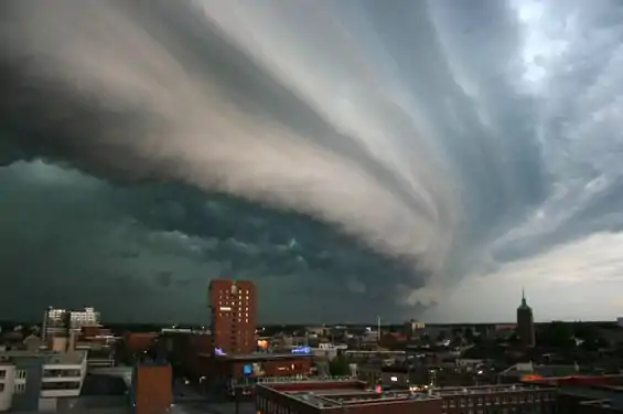
Rolling thunder cloud

Cyclone Gafilo
Mammatus cloud

Dust Bowl
More weather-related Featured Pictures...

- Retired Pacific hurricanes
- Hurricane Dean
- Hurricane Isabel
- 1998 Pacific hurricane season
- Hurricane Dean
- Retired Pacific hurricanes
- 2003 Atlantic hurricane season
- More weather-related Featured Topics...

Feat. article candidates:
- Tropical Storm Ileana (2018) (Discussion)
Featured list candidates:
Feat. picture candidates:
Other candidates:
- Featured Article Review: 2005 Atlantic hurricane season (Discussion)
- Featured List Removal Candidate: List of storms in the 2005 Atlantic hurricane season (Discussion)

Subcategories

WikiProjects
The scope of WikiProject Weather is to have a single location for all weather-related articles on Wikipedia.
WikiProject Meteorology is a collaborative effort by dozens of Wikipedians to improve the quality of meteorology- and weather-related articles. If you would like to help, visit the project talk page, and see what needs doing.
WikiProject Severe weather is a similar project specific to articles about severe weather. Their talk page is located here.
WikiProject Tropical cyclones is a daughter project of WikiProject meteorology. The dozens of semi-active members and several full-time members focus on improving Wikipdia's coverage of tropical cyclones.
WikiProject Non-tropical storms is a collaborative project to improve articles related to winter storms, wind storms, and extratropical cyclones.
Wikipedia is a fully collaborative effort by volunteers. So if you see something you think you can improve, be bold and get to editing! We appreciate any help you can provide!
Associated Wikimedia
The following Wikimedia Foundation sister projects provide more on this subject:
-
 Commons
Free media repository -
 Wikibooks
Free textbooks and manuals -
 Wikidata
Free knowledge base -
Wikinews
Free-content news -
 Wikiquote
Collection of quotations -
 Wikisource
Free-content library -
 Wikiversity
Free learning tools -
 Wiktionary
Dictionary and thesaurus
Other Portals
-
 List of all portalsList of all portals
 -
 The arts portal
 -
 Biography portal
 -
 Current events portal
 -
 Geography portal
 -
 History portal
 -
 Mathematics portal
 -
 Science portal
 -
 Society portal
 -
 Technology portal
 -
 Random portalRandom portal
 -
 WikiProject PortalsWikiProject Portals
What you can do
 |
Here are some tasks awaiting attention:
|